
Previous pages / これまでのページ
# 1 Mt.Fuji – the father of Tokyo’s plateau / 富士山 – 東京の台地の父
# 2 The plateau – “Musashino Daichi” / 東京の台地 – 「武蔵野台地」
# 3 Tama River – the mother of Tokyo’s plateau / 多摩川 – 東京の台地の母
This page / このページ
# 4 Maps & Geography / 地図と地理 – 地図で見る日本の地形
Click the bird picture to return to homepage / ホームページへは鳥の写真をクリック
1The Japanese archipelago and Tokyo
Check the shape of the archipelago and the location of Tokyo with the map below. / はじめに日本列島及び東京の位置を確認
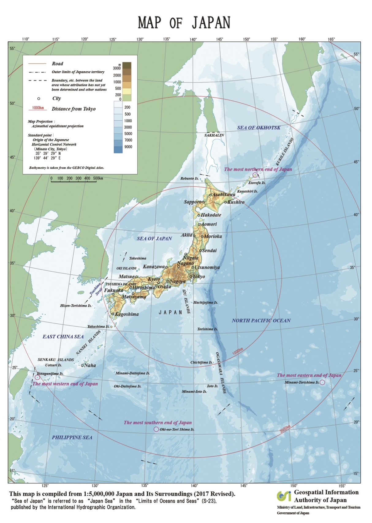 地図の出典:国土地理院ウエブサイト / Source of the map : the GSI web site, Government of Japan
Birth of the Japanese archipelago
日本列島の誕生
From 19 million years ago through 15 million years ago, the eastern extremity of Eurasia tore and the Sea of Japan and the Japanese archipelago was created. At the same time, a force was applied to bend the archipelago to form an arch, so that a large rift zone called Fossa Magna ( great ditch ) emerged in the middle of the main island ( Honshu ) of the archipelago. All these events are thought to be caused by the subduction of a oceanic plate under the Eurasia Plate. … Click to read more about the plate techtonics on the periphery of Japan.
いまから1900万年前から1500万年前までの間に、ユーラシア大陸の東縁が分裂し、日本海と日本列島が出来た。また、その際、日本列島を弧状に曲げる力が働き、本州の中央部に、大きな地溝帯(フォッサマグナ)が出来た。これらの出来事は、いずれも、大陸プレートであるユーラシアプレートの下に、海洋プレートが沈み込んだことによって、もたらされたと考えられている。・・・日本周辺のプレートテクトニクスについて、もっと読む。
Shaded elevation map of Japan / 陰影起伏図
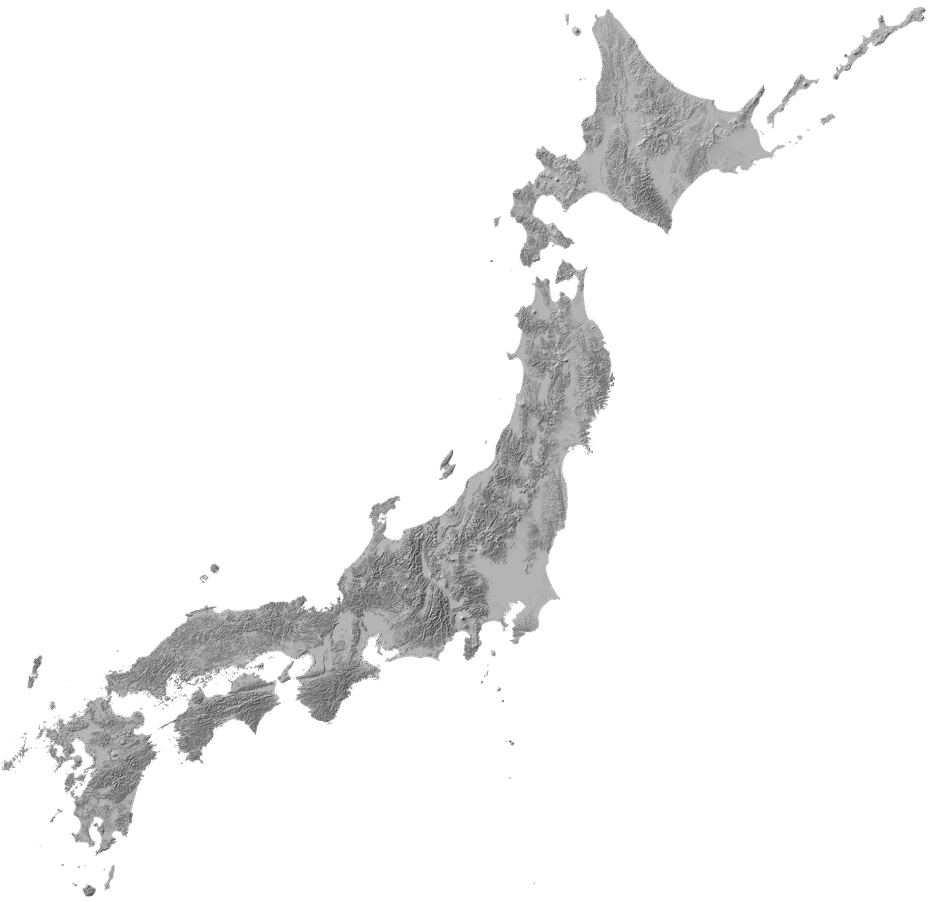
出典:国土地理院ウェブサイト「地理院地図」(陰影起伏図) / Source of the map : GSI Map, the GSI web site ( the shaded elevation map )
With the map above, the following observations can be made.
・ Kanto Plain, upon which Tokyo is situated, is the largest plain in Japan.
・ How the Itoigawa-Sizuoka Tectonic Line, a long fault which marks the western edge of Fossa Magna, runs north and south in the midland Honshu.
・ The location of Izu Peninsula and Mt. Fuji.
・ How a very long fault ( Central Tectonic Line – the CTL ) runs east and west along the layered belts of accretionary prisms of southeastern Japan.
・ How the CTL has been bent north at the western foot of Akaishi Range ( Southern Alps ) by the collision with Izu arc.
上の地図により、次の事項が観察できる。
・ 「関東平野」が、日本最大の平野であること
・ フォッサ・マグナの西縁を画する長い断層(糸魚川・静岡構造線)が、本州中央部で南北に走る様子
・ 伊豆半島と富士山の位置
・ 非常に長い断層(「中央構造線」)が、層をなす付加体の帯に沿い、西南日本を東西に走る様子。
・ 伊豆弧との衝突により、赤石山脈(南アルプス)の西側の麓で、中央構造線が北に折れ曲がっている様子
2 Kanto Plain & its vicinities / 関東平野とその周辺
The Map below is an enlargement of midland Honshu ( the main island of Japan). The names and jurisdiction of respective political units ( prefectures and a metropolis ) are indicated. The colored elevation map of the region is also superimposed. The map shows, among others, that the west, the middle, and the east of Tokyo Metropolis are, respectively, mountains, plateau and lowland. / 下の地図は、本州中央部の都県区分図と彩色標高図を重ね合わせたもの。
東京都は、西部が山地、中央部が台地、東部が低地になっていることが分かる。
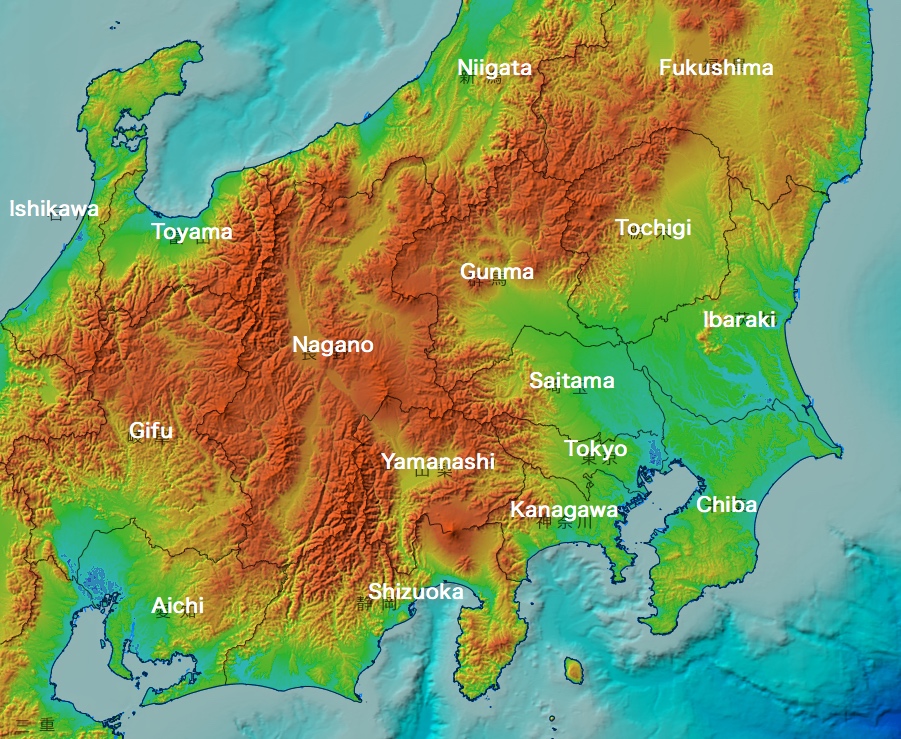 地図の出典:国土地理院「地理院地図」(白地図と彩色標高図を重畳。都県名の英語注記は編者による。) / Source of the map : GSI Map, the GSI web site ( the colored elevation map and the blank map superimposed, with notes by this editor )
In the map below, the coloration is made so as to further emphasize the difference of elevation. The map shows that the lowland to the north of Tokyo Bay is the mouth area of a very large river system ( Arakawa – Tonegawa River System ). / 下の地図では、標高差をさらに強調する彩色がなされている。東京湾の北側の低地が、非常に大きな水系(荒川・利根川の水系)の河口地帯であることが分かる。

地図の出典:国土地理院ウエブサイト(技術資料D1-No.766) / Source of the map : the GSI web site
3 Tokyo Metropolice / 東京都
Tokyo Metropolis consists of 23 wards ( ku or 区 ), 26 cities ( shi or 市 ), 3 towns ( cho or 町 ) and a village ( mura or 村 ). In the map below, the names of wards, cities, towns and village are indicated with respective different colors. Recently, however, the word “ku” ( 区 ) is often translated as “city”. / 東京都は、23区、26市、3町、1村から成る。下の地図では、区、市、町村の名称をそれぞれ異なる色で表記した。ただし、区は、近年、city と英訳されることが多い。
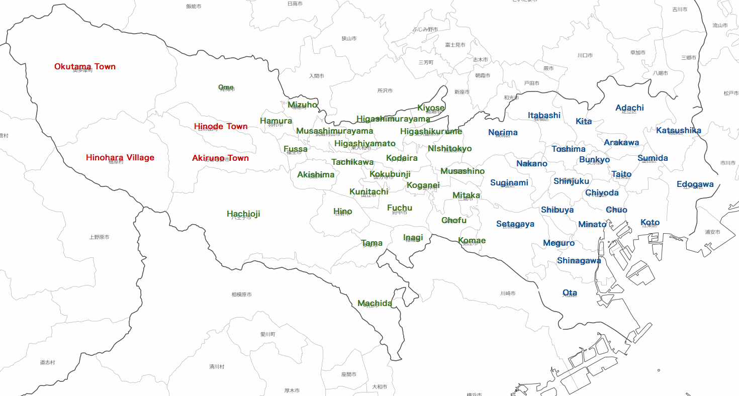
地図の出典:国土地理院「地理院地図」(白地図。区市町村名の英語注記は編者による。) / Source of the map : GSI web site, Government of Japan. The notes are by this editor
The map below is a colored elevation map of the same area. Lake Okutama, situated in Okutama town, the westernmost town in Tokyo Metropolis is a reservoir constructed 1957 by damming up Tama River for the purpose of water service.
下の地図は、同じ区域の色別標高図。東京都最西部の町、奥多摩町にある奥多摩湖は、1957年、多摩川を堰き止めて作られた水道事業用の貯水池。
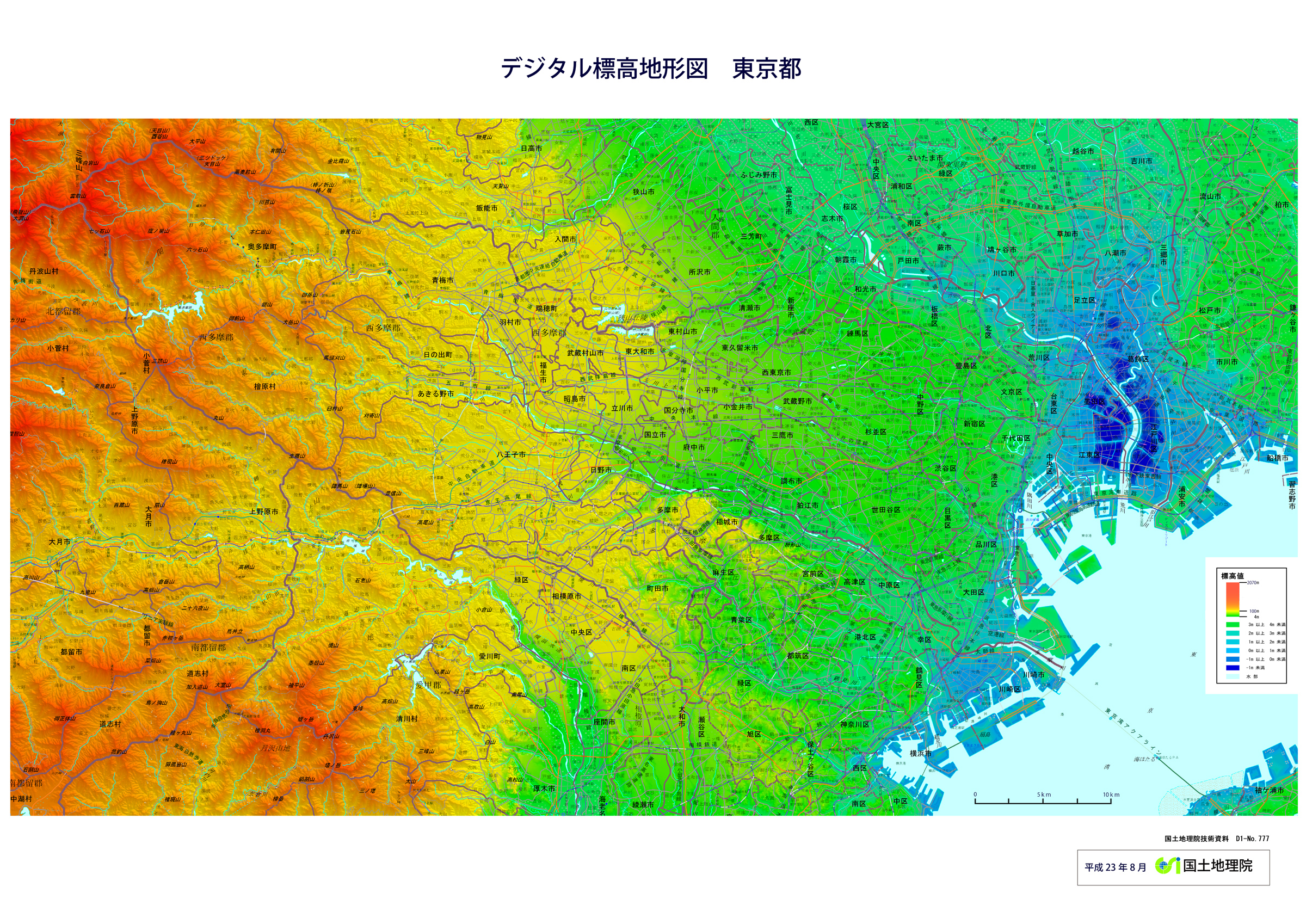
地図の出典:国土地理院ウエブサイト(技術資料D1-No.777) / Source of the map : GSI web site, Government of Japan
4 Downtown Tokyo / 東京都心部
The map below is a colored elevation map of downtown Tokyo ( ku or ward area ), with an added emphasis on the difference of elevation.
There are some areas in the eastern lowland where the elevation is below zero meter, which is a result of the land subsidence caused by the excessive ground water pumping in the past for industrial purposes.
On Tokyo Bay coast, there is vast reclaimed land.
The western half of the map is the eastern part of Musashino Plateau. Notice undulating terrain carved by dendritic valleys.
下の地図は、東京の都心部(区部)の彩色標高図。上の地図に較べ、標高差を強調する彩色がなされている。
東側の低地には、標高が0メートルを下回っている区域がある。これは、過去の産業目的の地下水の過剰な汲み上げが引き起こした地盤沈下によるものである。
東京湾岸には、広大な埋立地がある。
地図の西半分は、武蔵野台地の東部である。樹木状の谷[複数]に刻まれた、起伏の多い地形に注目。
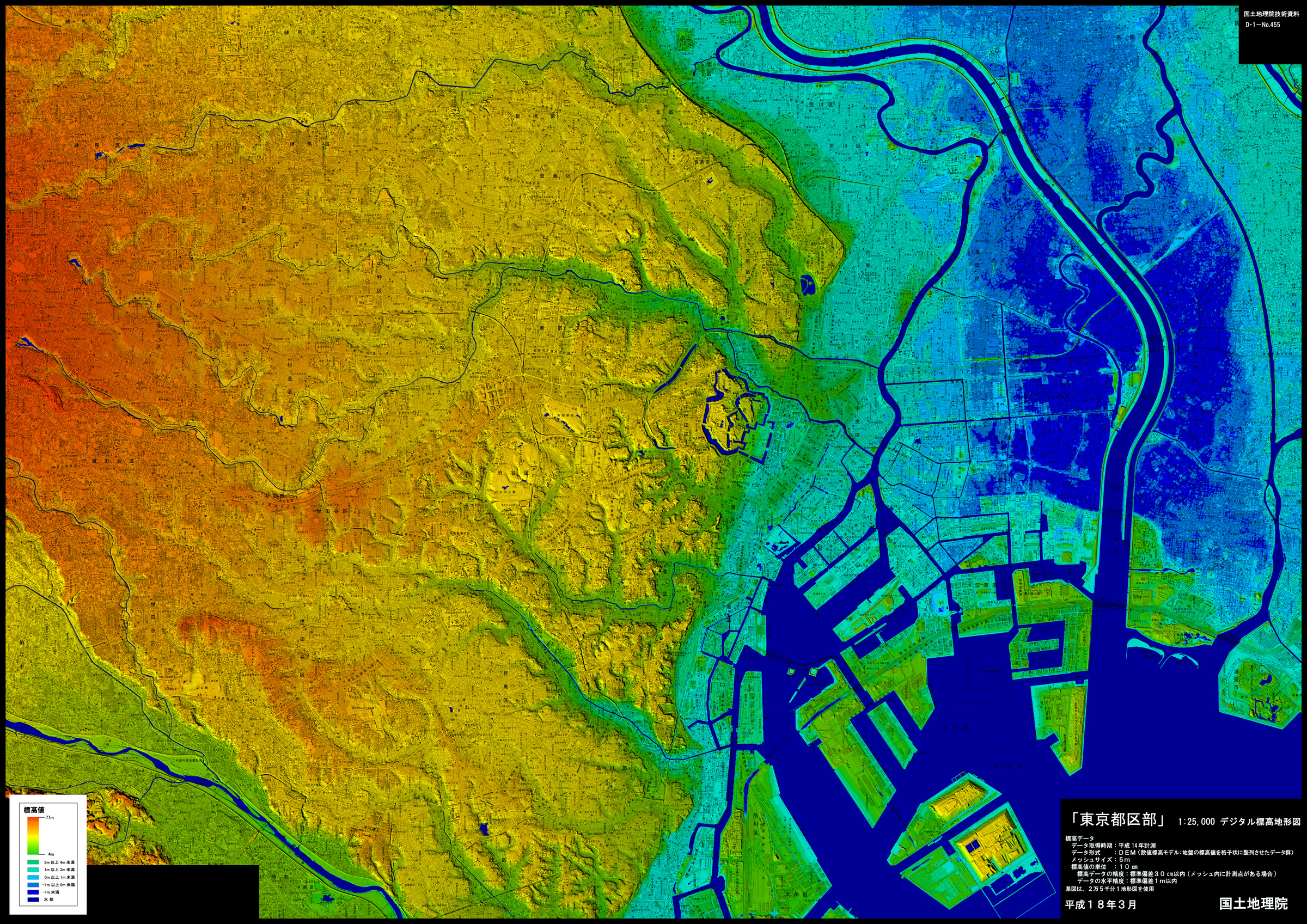
地図の出典:国土地理院ウエブサイト「東京都区部」(デジタル標高地形図) / Source of the map : GSI web site, Government of Japan
The ponds seen at the left end of the map are the sources of the rivers that runs east and west on Musashino Plateau . All these rivers, namely Kanda River, Zempukuji River and Shakujii River, are remnants of Old Tama River. … Click to read more about natural history of Musashino Plateau ( glacial eustasy and Old Tama River’s transition to the south ). / 地図の左端にある池[複数]は、武蔵野台地を東西に流れる川[同]の水源である。これらの川(神田川、善福寺川、石神井川)は、いずれも、古多摩川の名残川である。・・・武蔵野台地の自然史(氷河性海面変動と古多摩川の南遷)について、もっと読む。
The place surrounded by moats situated at around the center of the map is Kokyo ( the Imperial Palace ). Before 1868, Tokyo was Edo and Kokyo was Edo Castel ( Edo-jo ). … Click to read more about the geography and natural history of Kokyo / Edo-jo. / 中央付近の堀で囲まれた場所が皇居。1868年以前、東京は江戸であり、皇居は江戸城だった。・・・皇居(/江戸城)の地理と歴史について、もっと読む。
Previous pages
# 1 Mt.Fuji – the father of Tokyo’s plateau / 富士山 – 東京の台地の父
# 2 The plateau – “Musashino Daichi” / 東京の台地 – 「武蔵野台地」
# 3 Tama River – the mother of Tokyo’s plateau / 多摩川 – 東京の台地の母
#4 This page – to the top / このページのトップへ
Click the website title below to return to homepage / ホームページへは下のサイト名をクリック