
– Glacial eustasy and the southerly transition of Old Tama River –
武蔵野台地の自然史
氷河性海面変動と多摩川の南遷
Present-day Tama River flows along the southern end of Musashino Plateau. On the contrary, however, Old Tama River, which existed 130 – 120 thousand years ago ( during the last interglacial maximum ), flew along the northern end of present-day Musashino Plateau, that is to say north of Sayama Hill (See the map below).
多摩川は、現在、武蔵野台地の南縁を流れている。しかし、今から13−12万年前(最終間氷期最盛期)に存在した古多摩川は、これと反対に、台地の北縁(狭山丘陵の北)を流れていた。
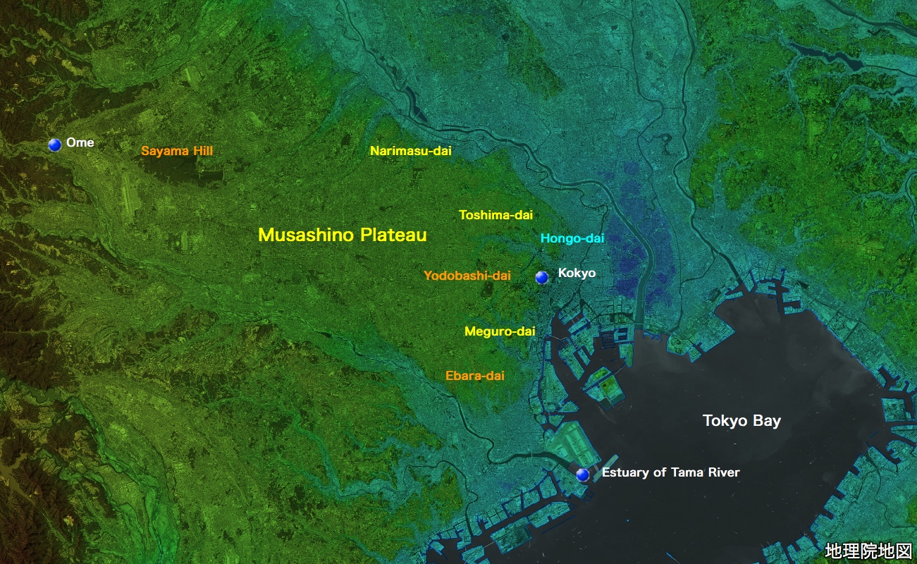
間氷期の東京湾と古多摩川 / Tokyo Bay and Old Tama River during the interglacial
It was a peak period of global warming between the last major glaciation ( Würm Glaciation ) and the second last major glaciation ( Riss Glaciation ) .
The sea level then was about several meters higher than that of today.
For this reason, Bay of Tokyo was much larger than it is today and the wide area of Kanto Plain was covered by the shallow sea; for example, the areas indicated in the map above as Narimasu-dai, Toshima-dai, Hongo-dai, Yodobashi-dai, Meguro-dai, Ebara-dai, all of which are now the parts of Musashino Plateau, were the in the bottom of shallow sea. Tokyo Bay in this period is called Old Tokyo Bay. Old Tokyo Bay was connected with the Pacific Ocean at present-day northern Chiba Prefecture and southern Ibaraki Prefecture and the hilly peninsula of southern Chiba Prefecture is thought to have been an island.
Under such geographical condition, Old Tama River flew into Old Tokyo Bay at much more northerly location than today.
その頃は、最後の大規模な氷期(ヴュルム氷期)と、そのひとつ前の大規模な氷期(リス氷期)の間の、温暖化のピークに当たる時期だった。
地球の海面高度は、現在より数メートル高かった。
このため、東京湾は、現在よりずっと広くなっており、関東平野の広い範囲が、浅い海で覆われていた(例えば、上の地図で、成増台、豊島台、本郷台、淀橋台、目黒台、荏原台と表示されている場所〜いずれも今日の武蔵野台地の一部〜は、浅海底だった)。この頃の東京湾は、「古東京湾」と呼ばれている。古東京湾は、現在の千葉県北部、茨城県南部で外洋(太平洋)と繋がっていて、房総半島の丘陵部は、島だったと考えられている。
古多摩川は、このような地形の中で、現在よりかなり北の位置で、古東京湾に注いでいた。
ヴュルム氷期の到来と海面低下 / The advent of Würm Glaciation and the sea level fall ( transgression )
Thereafter the global climate began to cool down.
The continents in the north America and Europe came to be covered with snow all year round and the snow formed glaciers. Würm Glaciation arrived. The glaciation progressed gradually over more than 100 thousand years repeating the alternation of stades and interstades. As the proportion of water on Earth which remained on the continents as snow or ice and did not return to the sea increased, the sea level on Earth in turn lowered gradually, repeating the alternation of small scale transgressions and regressions.
20 thousand years ago, the glaciation reached its maximum. The sea level then was about 130 meters lower than that of today. Old Tokyo Bay had disappeared completely ant the whole Kanto Plain including the bottom of Old Tokyo Bay had emerged as land. At the bottom of the valley which used to Old Tokyo Bay, a gigantic river which is called Old Tokyo River was flowing southward. All the rivers that flow into Tokyo Bay today, including Tama River, fell into Old Tokyo River, which flew into open sea ( the Pacific ) at the present-day channel between Kanagawa Prefecture and Chiba Prefecture ( Uraga Channel ).
その後、地球は、寒冷化しはじめた。
北アメリカ、北ヨーロッパの大陸が、一年中、雪で覆われるようになり、その雪が、氷河を形成した。ヴュルム氷期の到来である。寒冷化は、前進、後退(亜氷期、亜間氷期の交代)を繰り返しつつ、10万年以上にわたり、徐々に進んだ。その結果、地球上で、雪や氷の状態になったまま海に戻らなくなった水の割合が増大し、海面高度は、小規模な前進・後退を繰り返しつつ、徐々に低下していった。
ヴュルム氷期は、2万年前、ピーク(極相期)を迎えた。
このとき、海面高度は、現在より130メートルも、低くなっていた。
このため、古東京湾はすっかり姿を消し、東京湾を含む関東平野全体が陸地となって、かつて東京湾であった谷の最深部を、「古東京川」と呼ばれる、1本の大河が南向きに流れていた。古多摩川を含め、現在東京湾に注いでいる川は、すべて古東京川に注ぎ、古東京川は、現在の東京湾の外洋への出口(浦賀水道)で、外洋に注いでいた。
古多摩川の南遷と武蔵野台地の形成 / The southerly transition of Old Tama River and the formation of Musashino Plateau
During the 100 thousand years between the advent of Würm Glaciation and its maximum, Old Tama River gradually transferred its channels to the south, creating alluvial fans on the wide area of the land which is Mushashino Plateau today. Theses alluvial fans, for the reasons such as the sea level fall ( regression ), the transition of the river channels and the upheaval of land, emerged as land and formed the base of Musashino Plateau. Upon their emergence as land, Mt. Fuji, whose volcanism became active some 100 thousand years ago, piled up its ashes on them.
As late as 20 thousand years ago ( the maximum of Würm Glaciation ), Old Tama River had been flowing almost on the same route as the present-day Tama River does, leaving many remnants on the plateau.
Incidentally, the climate of Japan during the glacier period is thought to have been colder than today, but that does not mean that Japan was covered with snow or ice all the year round. In Japan, the glacier developed only at very limited places such as high mountains of the Japanese Alps even during the ice ages.
古多摩川は、ヴュルム氷期の到来から極相期到達までの10万年の間に、流路を徐々に南に遷し、現在の武蔵野台地の広い範囲に、扇状地(複数)をつくった。これが、今日の武蔵野台地の基盤である。
古多摩川は、ヴュルム氷期極相期(2万年前)には、台地上に幾つもの名残川を残しつつ、ほぼ現在の流路に近いところを流れるようになっていた。
なお、氷河時代の日本の気候は、現在より寒冷であったと考えられているが、通年、雪や氷に覆われていた訳ではない。日本では、氷河は、日本アルプスの高山等、ごく限られた場所だけにしか、発達しなかった。
淀橋台地 / Yodobashi-dai ( Yodobashi Plateau )
On Musashino Plateau, there are some parts where the bottom of shallow sea water of Old Tokyo Bay emerged as land early and acquired enough elevation not to become the channels of Old Tama River. Yodobashi-dai (* 1), which emerged out of Old Tokyo Bay 120 thousand years ago, is one of such places (*2). At these places, as the piling up of volcanic ashes began earlier, the bed of ashes is thicker then other parts of the plateau ( more than 10m ), at the lower part of which the proportion of ashes originated from other volcanos than Mt.Fuji, such as Hakone, which was more active in those years, is larger.
*1/ The scope of Yodobashi-dai
Yodobashi-dai extends from the west of Kokyo via JR Shinjuku Sta, to the southern part of Suginami-ku (Takaido ). It includes the greater parts of Shibuya-ku and Minato-ku, and the portions of Shinjuku-ku, Chiyoda-ku, Setagaya-ku etc.
*2/ The channels of Old Tama River
In the map above, the areas indicated with yellow letters became the channels of the river, while the areas indicated with orange letters did not. The area indicated with light blue, on the other hand, is thought to have become the channels of other river system ( Arakawa – Tonegawa river system ).
武蔵野台地には、古東京湾の海底が早期に陸化して十分な高度を獲得した結果、古多摩川の流路とならなかった部分が存在する。12万年前に離水した「淀橋台地」(注1)は、そうした場所のひとつである(注2)。
このような場所では、他の場所より早く火山灰の堆積が始まったため、火山灰の地層が特に厚く(10メートル以上)、その下層部では、箱根火山など、富士山より古い時代に活発だった火山に由来する火山灰の割合が高くなっている。
注1/淀橋台地の範囲
皇居の西側からJR新宿駅を経て杉並区南部(高井戸付近)に至る台地で、渋谷区・港区の大部分と、新宿区・千代田区・世田谷区などの一部を含む。
注2/古多摩川の流路
上の地図で、黄色の文字で示された区域は、古多摩川の流路となったが、橙色の文字で示された区域は、ならなかった。また、淡青色で表示された区域は、別の水系(荒川・利根川水系)の川の流路となったと考えられている。
後氷期の東京〜東京低地の形成 / Tokyo in the postglacial – the formation of Tokyo Lowland
The thaw of glacier after the maximum of Würm Glaciation progressed much faster than its formation, which took more than 100 thousand years. Consequently, the sea level of the earth rose rapidly up to a couple of meters higher than that of today from 130 meters below today’s zero at the maximum of the ice age, over the period of 13 thousand years between 20 thousand years ago and 7 thousand years ago. Since 7 thousand years ago to date, the sea level has been falling again.
During this period ( that is to say from 20 thousand years ago to date, which is called Holocene ), the sea level change and the force of rivers changed the topography of Tokyo to a large extent. For instance, in the drainage basin of Tonegawa – Arakawa river system, the vast valley formed during the ice age was gradually filled at is entry to the sea with the earth and sand transported downstream by the rivers while the large scale sea level rise was in progress. Thereafter, with the sea level fall which began 7 thousand years ago, the deposits at the estuary then emerged as land and formed Tokyo Lowland.
ヴュルム氷期極相期後の氷河の融解は、10万年以上かけて行われた氷河の形成に較べると、ずっと早く進んだ。すなわち、今から2万年前から7000年前までの1万3000年の間に、地球の海面高度は、現在よりも130メートル低い水準から、数メートル高い水準にまで、急速に上昇した(縄文海進又は有楽町海進)。その後、海水準は、7000年前(縄文時代)に低下に転じ、現在の高さに至っている。
この間(2万年前から現在までの間)、海水準の変動と河川の作用(侵食、堆積等)が、東京の地形を大きく変えた。例えば、利根川・荒川水系の流域では、氷河時代に作られた大きな谷が、海進が進むなか、河川が上流から運んだ土砂で、河口部から徐々に埋め立てられていった。7000年前以降の海退により、こうした河口部の沖積土が離水し、東京低地となった。